Sunday, 12 October 2014

DAY BY DAY ACCOUNT OF MY 2011 NAMIBIA TRIP - DAY 10 (2011-05-22)

See the previous installments at http://groblerdupreez.blogspot.com/


Ruacana Falls


Last night we camped at the Hippo Pools Camping site. Up early and off without breakfast to catch the sun rising at the Ruacana Falls.

Rene deciding what to paint

A more dramatic studio could not be imagined...


A spectacular sunrise at the top of the Falls

Marlene preparing breakfast near the main viewpoint. The fence visible to the left is the Namibia - Angola border.

Marlene and Rene enjoying the magnificent scenery
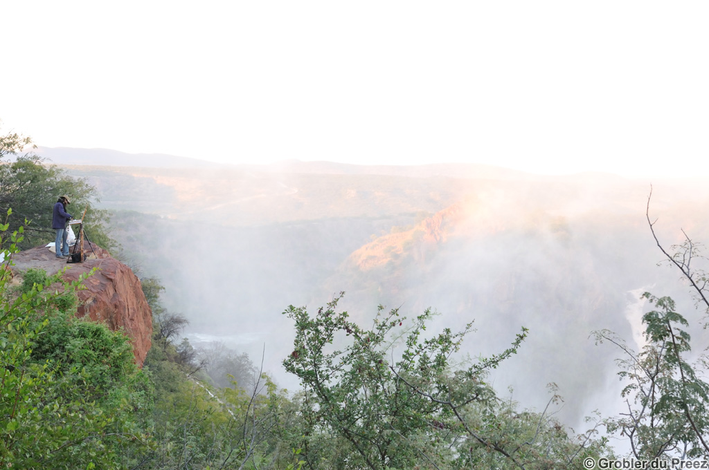
Rene busy with another painting as the sun is starting to set over the falls.

Back to the Hippo Pool for a lovely sunset and an enjoyable evening next to the camp fire

Distance traveled for the day: 42 km including a trip to the Ruacana town for some groceries

The map below is an interactive Google Map showing the actual GPS track we followed, imported from a .gpx file. Zoom in to follow our route. Double click on a balloon for more information.

Monday, 22 September 2014

DAY BY DAY ACCOUNT OF MY 2011 NAMIBIA TRIP - DAY 9 (2011-05-21)

See the previous installments at http://groblerdupreez.blogspot.com/


Outapi (Ombulantu Baobab tree) - Ruacana Falls


We camped the previous night below the baobab tree. Early up to get a few shots during the golden hour...

...and then breakfast at our camp below the Ombalantu Baobab Tree.
We took a guided tour of the tree. The tree is naturally hollow inside and can seat about 20 people. See more of it's rich history: Ombalantu


Marlene and Rene studying the visitor's book inside the tree

We departed to Ruacana Falls, 15 km past the town of Ruacana. From Ruacana, the road descends quite steeply to the Falls. The Calueque Dam in Angola is visible in the distance.

The Kunene River drops into a 700m wide x 120m deep ravine just below the Calueque Dam.

Marlene and Rene enjoying the view.


We set up camp at the Hippo Pools, a few km's below the falls

Lunch at Hippo Pool campsite. Quite hot in the middle of winter...

Back to the falls after lunch - here Rene is busy with a colour study of the falls from the viewpoint at the hydroelectric power station.


...then a colour study at the top of the falls... To reach the main viewpoint, you have to go throught the border post on the Namibian side - no formalities if you only visit the falls.

A Baobab tree in the falls

Sunset on top of the falls
Distance traveled for the day:  100 km, all tar

The map below is an interactive Google Map showing the actual GPS track we followed, imported from a .gpx file. Zoom in to follow our route. Double click on a balloon for more information.


Tuesday, 9 September 2014

DAY BY DAY ACCOUNT OF MY 2011 NAMIBIA TRIP - DAY 8 (2011-05-20)

See the previous installments at http://groblerdupreez.blogspot.com/


Etosha (Halali) - Outapi (Ombulantu Baobab tree)


Up early and off to the Moringa waterhole. No animals, so back to camp for breakfast. Break up camp then off to Ruacana via Namutoni, hoping to see elephants.

Apart from giraffes "necking" and "butting" and a few lions hiding between bushes on route to Namutoni, not much to see.

Except for thousands of flamingoes on the pan in the distance, not many birds either. 
An unidentified plover

A young Impala male

Fort Namutoni, a rest camp in Etosha. For more information on it's rich history see Namutoni

"On 28 January 1904, 500 Ovambos attacked the station.  Seven brave German riders repelled the attack"

The King Nehale waterhole as seen from the top of the wall of Fort Namutoni

Inside Fort Namutoni

From Namutoni, we traveled NorthNot many animals - no elephants. Not a good year to visit Etosha - the best rain year in history caused a lot of open water in the veld, resulting in few animals visiting the waterholes. Lots elephant dung. Our companion, Rene, said that she doesn't believe us that there are elephants - "the park rangers pick up elephant dung from elsewhere and dump it all over so that the visitors should think there are many elephants"!

We exited Etosha at the King Nehale Gate in the north and suddenly there were many animals, but not the type I prefer to see. Our companion, however, grew up on a farm and during the next few weeks we would learn that it would be impossible to drive past a herd of cattle without stopping...

At Oshikati, we bought lunch and supplies. The flowing water in this photo is not a river, but an oshana in Oshakati, one of many perennial watercourses (linearly-linked, shallow, parallel lakes), Once every few years, during exceptional rains, the oshanas fill with rainwater and sometimes with floodwater from the perennial Cuvelai River in Angola. Have a look at the area above Etosha on the interactive map further below to see this interesting phenomenon. The fish which breed in the oshanas provides an important source of dietary protein to the local population. Here they are using traps to catch fish.

We were aiming for Ruacana, but realised that we would not reach it before dark. We decided to camp at the Ombalantu Baobab tree at Outapi. Only us in the camp. No staff. The attendant gave us the gate keys before she left and we only realised the following morning that it included the keys to the curios shop and office. The people in Namibia are very trusting... We fell asleep to the sounds of farm animals and indigenous music...

The tree is hollow inside and is currently configured as a small church chapel which could seat approximately 20 people.

Distance traveled for the day:  360 km of which 139 km were gravel road.

The map below is an interactive Google Map showing the actual GPS track we followed imported from a .gpx file. Zoom in to follow our route. Double click on a balloon for more information.

Monday, 1 September 2014

DAY BY DAY ACCOUNT OF MY 2011 NAMIBIA TRIP - DAY 7 (2011-05-19)

See the previous installments at http://groblerdupreez.blogspot.com/


Etosha


Still at Halali. Up early and off to the Moringa waterhole. No animals, so back to camp for breakfast then off for a round trip through Etosha. Due to the exceptionally good rains, we saw very few animals. Even Springbokvlakte, which usually is littered with animals, was without animals.

Springbok lying in the grass

Patches of red and purple plants between the grass fields.

Picnic spot at Olifantsbad. waterhole

An unusual sight - the Etosha Pan full of water. This is the road to the viewpoint on the pan.
The Etosha National Park is a 22 750km² wildlife sanctuary. Etosha, meaning ‘place of dry water’, gets it's name from a large, flat calcrete pan of about 110 km x 45 km. The pan is subject to periodic, partial flooding during the rainy season. Direct rainfall accounts for only a small proportion of the pan’s water; three rivers supply the majority: the Ekuma, Oshigambo, and Omuramba Ovambo. The Ekuma River flows seasonally from the southern shores of Lake Oponono, situated about 70 km north of the pan. This lake receives input from numerous perennial watercourses and oshanas (linearly-linked, shallow, parallel lakes), the Cuvelai River being the most important (Berry et al. 1973). The Oshigambo River draws its water from southern Angola. The Ekuma and Oshigambo Rivers form deltas in the northwestern corner of the pan, about 13 km apart. The Omuamba Ovambo River receives its water from a catchment to the northeast of Etosha, and it flows into the pan through Fisher’s Pan, a small eastern extension of the main pan body. All three rivers flow erratically during the rainy season and, depending on their levels, flood the pan to varying degrees. In unusually dry years, the rivers may not flow at all, forming a series of disconnected pools. During these dry years, the pan holds direct rainfall only. The pan does, however, usually hold some water for a few months between January and April. Once in about 7-10 years, during exceptional rains, the oshonas and rivers fill with rainwater and sometimes with floodwater from the perennial Cuvelai River in Angola. This water reaches the pan, transforming it into a shallow lake holding large sheets of water, usually not exceeding one meter in depth. The water in the pan is, however, unfit for animal consumption as the salt content is often double that of sea water (Source of information). Have a look at the area above the pan on the interactive map further below to see this interesting phenomenon.

Waiting for the golden hour at Halali.

Lions at the lit Moringa waterhole at Halali.

Waiting at the waterhole til late - but no elephants visited. Dropped my Nikon SB800 flash in the dark on the rocky floor - not working any more...

Total distance covered today: 190 km, all gravel roads.

More to follow...

The map below is an interactive Google Map showing the actual GPS track we followed, imported from a .gpx file. Zoom in to follow our route. Click on a balloon for more information.

Monday, 25 August 2014

DAY BY DAY ACCOUNT OF MY 2011 NAMIBIA TRIP - DAY 6 (2011-05-18)

See the previous installments at http://groblerdupreez.blogspot.com/


Windhoek to Etosha

Breakfast, breaking up camp and then on to Morua Mall to sort out our mobile internet connection. Then we hit the road to Etosha.

Not much to see en route. The only landmarks were the Omatakos in the distance, rising between 700 and 800m above the surrounding plains. Apparently, the Omatakos are so-named in Otjiherero for their resemblance to a woman’s buttocks, but it rather resembles another body part - the peaks are too sharp...

A quick stop in Otjiwarongo for fuel and something to eat and then a short detour through town to see two of the houses where Marlene lived with her parents before our marriage as well as the Otjiwarongo High School where Marlene finished high school.

Then off to Outjo where we also visited two of the houses where Marlene lived with her parents before moving to Otjiwarongo. Then a big mistake - visiting a gemstone shop where I could not get my two partners away from... The result - we are going to be late at Halali in the Etosha national Park.

Stretching our speed through the warthog infested road to Etosha, we reached Okaukeujo in time to pay our daily conservation fee of N$ 65.00 per person, but without sufficient time to reach Halali where our camping site is booked before gate closing time.

On our way to Halali we saw this semi-white elephant, but could only snap a few photos before speeding on...

We reached Halali approximately 20 minutes late, but the irritated receptionist did not give us a fine. Setting camp, a quick supper and then on to the lit Moringa waterhole a few 100 m away where several animals visited. Then off to sleep...

Total distance traveled: approximately 530 km, of which 70 km were gravel road.

More to follow...

The map below is an interactive Google Map showing the actual GPS track we followed imported from a .gpx file. Zoom in to follow our route. Click on a balloon for more information.

Sunday, 17 August 2014

DAY BY DAY ACCOUNT OF MY 2011 NAMIBIA TRIP - DAY 5 (2011-05-17)

See the previous installments at http://groblerdupreez.blogspot.com/

Windhoek

Breakfast and then off to find a launderette to wash our clothes and to do some shopping at Morua Mall. Then off to find spares for the inverter - fortunately, I only had to replace the 12-v plug that fits into the cigarette lighter socket - the one I fitted to the inverter cable back in Bloemfontein couldn't handle the current. Just to make double sure we won't again have to do mouth to mouth resuscitation to the inflatable mattresses, we bought a 12v pump.

On our way shopping, we passed by two of the houses I lived in with my parents during the 1960's and 70's. This one we lived in from 1965-1968. The tree to the left at the back of the house is a silver oak planted by my father in 1965. 

We lived in this house from 1968 to 1973

A quick visit to the Namibian Wildlife Resources office to book a camping site in Etosha, then down memory lane for more sightseeing.

My primary school, Orban Primary, then an Afrikaans/German double medium school, now state offices.

The Christuskirche, a well-known landmark in Windhoek. Scheduled tours to see the inside are available.

The Tintenpalast (German for "Ink Palace"), the Namibian parliamentary buildings

The Reiterdenkmal (Equestrian Statue) in front of the Alte Feste, the oldest building in Windhoek, now a museum. On 25 December 2013, the area in front of Alte Feste was cordoned off to prevent public and press from getting close and the statue was lifted off its plinth and transported into the yard of Alte Feste for storage and possible "repatriation" to Germany. To the local black population this statue represents oppression.

My secondary school, Windhoek High School next to the Alte Feste

Windhoek offers many interesting curio shops, coffee shops and old, German buildings. Worth spending several days exploring the city.

After visiting distant family of Marlene, we had an early supper and then hit the bed. Tomorrow it's off to Etosha...

Distance traveled for the day: 171km

More to follow...

The map below is an interactive Google Map showing the actual GPS track we followed imported from a .gpx file. Zoom in to follow our route. Double click on a balloon for more information.